A one-day quad outing in the Saint-Victor en Beauce area. A 160 km outing that includes many interesting discoveries along the way, as well as a few dams.
Quad riders in a gravel row in the Saint-Victor sector
|
Direction Domaine du Radar and a bit of history
This region is bursting with landscapes and points of interest that are well worth a visit. I’ve affectionately dubbed it “Quebec’s little Montana”. With mountains and valleys filled with cattle farms reminiscent of the popular American state.
We set off from Saint-Victor along the trails towards our first point of interest, Domaine du Radar. Along the way, we come across the village of Tring-Jonction, where you’ll find a number of services, such as gas and food. Saint-Victor and Domaine du Radar are only 25 km apart.
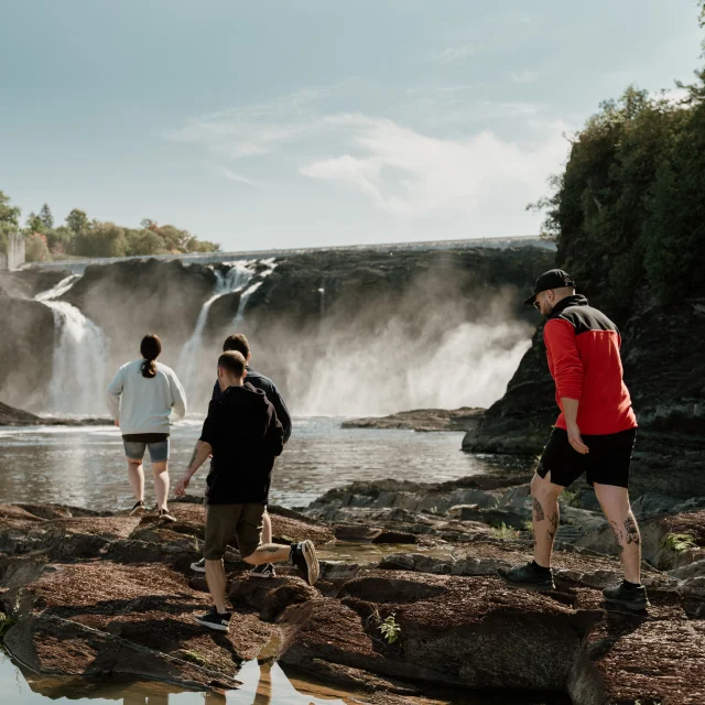
When you arrive at the Domaine du Radar gate, you’ll need to go to the gatehouse to pay your access fee of $5.95 per vehicle (in 2023), which will allow you to go up and down the mountain. The 2225-foot ascent will take you about ten minutes at low speed, as this is a shared trail with hikers, so caution is advised. At the top, the view is breathtaking! On one side, we can see Quebec City, and on the other, the mountains bordering the U.S. border.
A bunker perches atop this mountain, and not just any bunker. It’s a radar station built jointly in the 1950s by the federal governments of Canada and the United States out of fear of a Russian invasion from the north. After four years of construction employing up to 1,500 workers and an investment of over five million dollars, the six-hundred-acre military base opened its doors on September 15, 1953. In 1955, three towers were built to provide aerial surveillance of the region. Today, only the structure of the Top Secret tower remains at the summit. You can examine it from the outside. After taking several shots of this historic site, we head back down the mountain to join the trails to Saint-Clotilde-de-Beauce.
The view from the top is breathtaking! On one side, we can see Quebec City, and on the other, the mountains bordering the U.S. border.

Quad riders take a break at the Domaine du Radar bunker
|

The view from the summit of Mont Ste-Marguerite at Domaine du Radar
|

The view from the summit of Mont Ste-Marguerite at Domaine du Radar
|
Direction Barrage Arthur-Pomerleau (34 km)
The trails to Saint-Clotilde-de-Beauce are mountainous, wide and wooded. Along the way, you’ll come across some beautiful maple syrup facilities, easily spotted by the many blue pipes that wind through their wooded grounds. Along the way, you’ll come across the village of East Broughton, where you’ll have access to gas and a restaurant. Be careful when arriving in East Broughton at the corner of Route 112, as you’ll have to cross this busy road to reach the trails on the other side.
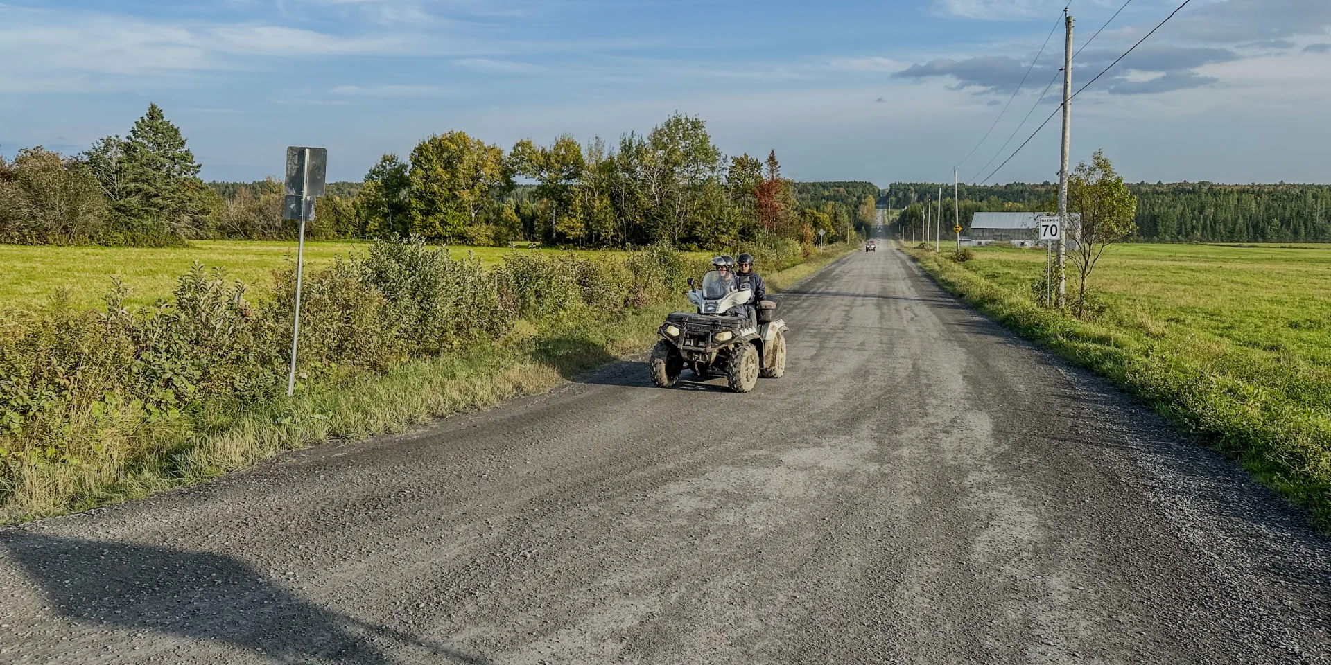
The trail to the dam is exclusively on gravel roads shared with road vehicles, of which there are few in this region. The straight route takes you through rolling landscapes dotted with beautiful valleys filled with grazing animals.
Once at the dam, the view is superb! You’ll have access to a large parking lot and facilities for enjoying a good lunch in nature. You can read about the structure, built in 1938. It overlooks the Rivière Prévost-Gilbert, which flows southeast for 31 km towards the Bras Victor, one of the major tributaries of the Rivière Chaudière.

Group of ATV riders stopping at Arthur Pomerleau dam
|

View of the Arthur Pomerleau dam
|
Direction Courcelles (45 km)
After a break at the dam, it’s time to get back on the trails and head for the municipality of Courcelles, at an altitude of 350 metres, on the Haute Beauce plateau. This village is located at the gateway to the Eastern Townships tourist region, on National Route 108 linking the Beauce and Eastern Townships.
Along the way, you’ll find a wide variety of trails. Narrow forest trails, mountain climbs and descents, gravel sectors and wetter areas make for an entertaining experience!
Along the way, you’ll come across the municipality of Saint-Méthode-de-Frontenac, where the St-Méthode bakery was founded in 1947. Gasoline and a restaurant are available in this municipality.
Leaving Saint-Méthode, take the 10th rang towards La Guadeloupe. At the intersection, before entering this municipality, you’ll turn right to head for Courcelles on narrower wooded trails.
In Courcelles, we have access to a magnificent riverside parking lot. This municipality of 800 inhabitants has made the most of its local history, first by restructuring the Bernier mill, a former saw and flour mill, to turn it into a tourist entertainment center featuring a variety of exhibits.
L’Espace Aux Rives du temps brings together four tourist attractions that are sure to impress.
- The Bernier mill, built in 1888 and renovated in 2003. It is a saw and flour mill built on the banks of the Bluets River.
- Lambton-Station wagon 1895. Built in 1895, this caboose was used on the rail line created after 1900 to link the Lac-Mégantic region to the Beauce.
- Maison-Atelier Tardif, built in 1904. This family business specialized in the manufacture of wooden objects.
- The Belvédère du Moulin, built in 1904. From here, you can admire the log dam and the Courcelles landscape.

Visitors to Espace Aux Rives du Temps
|

Barrage at Espace Aux Rives du Temps
|
Return to Saint-Victor (41 km)
After an hour’s break to visit these tourist attractions, it’s time to head back to Saint-Victor for the final segment of this itinerary. Your route will be almost entirely gravel.
Leaving Courcelles, you’ll retrace your steps for 12 km. You’ll also pass through the municipality of La Guadeloupe, named after the coronation of the Virgin of Guadalupe in Mexico. In early 1945, the cardinal vowed that, on his return, the next parish would be named Notre-Dame-de-La Guadeloupe.
Leaving this municipality, you’ll head for Saint-Évariste, then cross the village of Saint-Éphrem-de-Beauce via rang Saint-Jean-Baptiste. Founded in 1866, Saint-Éphrem-de-Beauce boasts a population of 2,400, proud of its sports and cultural facilities. A pavilion with picnic tables and toilets is at your disposal. You’ll also have access to a gas station and restaurant if needed.
Leaving Saint-Éphrem, it’s just 13.5 km to Saint-Victor and the end of your hike. We hope we’ve inspired you to visit this beautiful region.
Photos : Steve Maillet, Raven Média inc.

Quad riders in a gravel row in the Saint-Victor sector
|

ATV bridge in Saint-Éphrem-de-Beauce
|

Quad riders in a gravel row in the Saint-Victor sector
|
QUAD BIKING IN CHAUDIÈRE-APPALACHES
The region’s exceptional snow cover means that just over 2,300 km of trails can be covered in winter, and almost 1,900 km at other times of the year.
The trails, groomed and marked by 18 quad clubs, offer top-quality signage, as well as the possibility of doing magnifying glass or daisy chain runs, without ever riding the same trail twice.